HSI High Side Indicator – XSeries 


The new X-Series digitizer (AS272)* electronics have been recently implemented with a 3C solid state inclinometer system called a High Side Indicator (HSI), which measures the direction of the pull of gravity and calculates the angles of roll and vertical inclination in each shuttle of the Geochain toolstring.
HSI Orientation Guide PowerPoint
Main Features:
- Measures tool roll and inclination for every receiver for full 3-C geophone orientation
- Real time monitor read out and manual capture utility (along with internal electronics temperature)
- Automatic addition of HSI data to MIRF-6 header for each individual record
- The user can also manually capture the readout for all tools. (can be automatically correlated with WellTrack deviation listing in ACQ).
*When used with X-Generation Telemetry Adapter.
The new X-Series digitizer (AS272)* electronics have been recently implemented with a 3C solid state inclinometer system called a High Side Indicator (HSI), which measures the direction of the pull of gravity and calculates the angles of roll and vertical inclination in each shuttle of the GeochainTM toolstring.
The integrated system denotes tool inclination from vertical (DEV Angle 0-90°) and and clockwise roll looking downhole (Relative Bearing RB angle 1-359°).
Roll and inclination angles are determined from an accelerometer subsystem measuring the direction of the pull of gravity. If combined with a well deviation listing giving well azimuth trajectory (HAZI 1-359°), full 3-C processing can be achieve for all 3 components delivering a Vertical Up and Horizontal North/West field orientated dataset.
The current accuracy of the accelerometers tested for inclination measurement is ±0.1° with tool roll accuracy ±0.25° when positioned >9.9o from vertical.
The First rotation is that of the relative bearing (RB) angle, which is described in the plane orthogonal to the tool axis. RB is measure clockwise looking down from the vertical plane – borehole “high side” towards the direction of the arm opening Fig (a).

HSI Processing Steps for full 3C rotation

The integrated system denotes tool inclination from vertical and clockwise roll (looking downhole).
The example below shows the results comparing a raw correlated stack of a 3C near offset VSP dataset with that of a dataset with HSI roll values applied to the horizontal (X+Y) components.
A Full processing route guide for VSProwess will be released within the next Geochain User Manual. The HSI route guide v.1.3 can be downloaded here.
Please contact sales@avalonsciences.com for more detail.
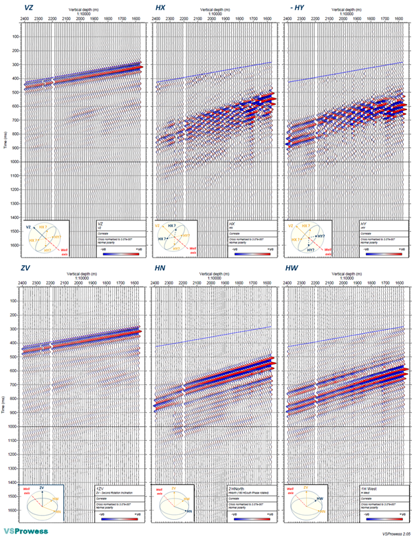
Top – Correlated raw common depth 3C stack plot in true amplitude, as recorded (no rotation applied). Bottom – After rotating the X,Y components with the highly erratic recorded HSI roll angle, showing a great coherency between adjacent depth levels.
ORDER THIS PRODUCT
CALL OUR SALES TEAM
+44 (0) 1458 270000
BOOK A TRAINING
COURSE
